Hi there,
We just wanted to extend a special thanks to High Country for making this a very special vacation. This was our first family rafting adventure and the kids loved it so much that we're already talking about next year.
Doug Caberra

Registered Guest Login
 

An HCE River Trip or Gear:
Give the perfect gift!


Join our Mailing List


Tell a Friend about High Country Expeditions.


Did you have a memorable trip? Please share your experience with others!


Site Map

Featured Rafting Trips and Rivers:
Upper Mckenzie River
Lower Mckenzie River
Upper-Klamath River
Cal Salmon River
Owyhee River
Rogue River

HCE Mckenzie River Rafting

Rivers > Upper Klamath River


View Directions
View River Levels
View Current Weather
View Pricing


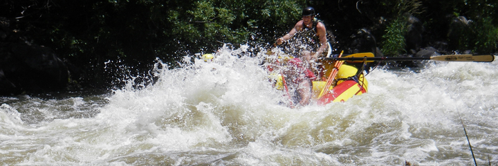
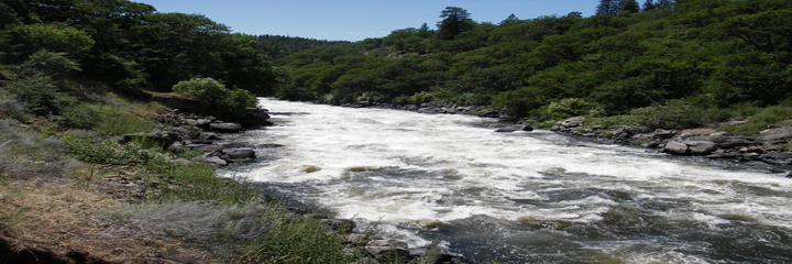
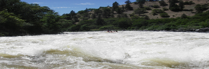
The Wild and Scenic "Hell's Corner" of the Upper Klamath offers non-stop, fun and exciting whitewater rafting, for most of the year. This upper most, 20 mile portion of the Klamath River is Oregon's only consistent, and without a doubt the best Class 4+ whitewater rafting experience throughout the summer. The section is located between 2 power generating dams, providing consistent water releases throughout the year.  This means great whitewater rafting. Located in the southern most region of Oregon and nestled between Klamath Falls & Ashland, the UK (as it is known) is close but very remote. Being one of the newest members to federally designated "wild & scenic" rivers in North America makes this adventure one to be experienced.

Upper Klamath River Trip Highlights
  • 40 plus exciting rapids
  • Warm water! (Very rare in the NW)
  • Spectacular scenery & wildlife
  • Family friendly whitewater adventure (12 years and older)
  • All inclusive trips: wet-suits, booties, lunch, shuttle...
  • Experienced guides & top-of-the-line gear!
  • Close to Ashland, Klamath Falls, Mt. Shasta, Crater Lake
  • Emphasis on Safety & Fun


  •  
    • Upper Klamath River Full Day Whitewater Rafting Trip
      Upper Klamath River Full day trip overview All Upper Klamath rafting trips launch at Spring Island boat ramp, located below John C. Boyel Dam. Trip launching times are coordinated with peak water releases from the Dam, ensuring optimal water levels and guaranteed excitement. The first 4 miles of the run consists of a few Class II & III+ rapids with mellow stretches and spectacular scenery. A true and timeless Old West allure is always present in this isolated and history rich filled canyon. Once you reach the canyon, the excitement of the "Hell's Corner" run begins with the first major rapid of the day. Caldera, a long, technical Class IV+ rapid, gets the adrenaline pumping and is followed by more than 40 thrilling (but not overwhelming) rapids intertwined with high, abrupt drops and non-stop breathtaking excitement. After having experienced some of the most exciting whitewater in the NW, we'll pull off the river approximately halfway through the Hell's Corner portion of the adventure for a wonderful and hearty gourmet lunch. High Country Expeditions is not just known for great river trips and professional guides, but also for our truly gourmet, fresh and delicious riverside meals. The meals are served right on the river bank, suited and designed to your needs by your guide. We also cater to most dietary needs and desires. After lunch it's time to get back in the saddle and ride the remaining and always exciting Upper Klamath rapids. Once out of the Canyon, you'll enjoy a 1-3 miles relaxing class 2 cool down period before the take-out. There are 3 access points to take out and these are determined by time and weather. High Country Expeditions also offers two-day rafting trips on this exciting portion of the river river. On our overnight trips, High Country Expeditions guests camp near the California/Oregon Stateline and enjoy a pleasant afternoon and evening by testing their skills at catching wild trout, swimming in the usually warm waters or just relaxing and discussing the day's run. On the second day we run the best six mile stretch again starting from the old Frain Ranch site and continuing until we reach Copco Lake. Because the water on the Upper Klamath is dam controlled, the levels are consistent throughout the summer and make this a popular late summer run. Upper Klamath River Location & brief description The Klamath river begins in the Cascades of southern Oregon near Klamath Falls and runs out of Klamath Lake down for approximately 17 mile into Copco Lake just south of the California-Oregon Border. Located along the Pacific Flyway, the Upper Klamath river provides habitat for an abundance of birds such as eagles, osprey, pelicans, herons and more. The Upper Klamath River carves its way through the volcanic Cascade mountain range, offering a glimpse into the Wild West of the past. Hell's Corner Canyon is full of old west flavor. High buttes crown the canyon rims, abandoned settler's cabins are visible on the banks and waterfalls and rapids are known by names like Hell's Corner, Wells Fargo, Gunsmoke, Stageline, Branding Iron, Wild Card, Jackass, Ambush and Ol' Bushwacker. This run offers some of the most exciting whitewater rafting on the west coast! Base Full-day rate $145.00 *Discounts available! Base Two-day rate $355.00 *Discounts available! *Youth - there is a 12 year age limit on this section of whitewater.* See pricing details Book a Trip Now
      Upper Klamath River History For many years before the first settlers, the Klamath River was home to the Karok, Modoc, and Yurok Indian tribes. The Klamath was the life blood of the Native Americans who relied on it for its abundance of salmon and trout. The name "Klamath" was derived from an Indian word "Tlamatl" which means "swiftness" in Chinook. The Gold Rush of 1850-51 brought many miners and left a rich history. The miners caused a terrible disruption in the lives of the Native Americans of the area by damming and diverting water for mining purposes, which made it difficult for spawning salmon and other fish populations. There are remnants of old mining sites, old hotels, brothels and hot spring resorts along the lower portion of the Upper Klamath river. Only a few years ago the Upper Klamath was known only to a private river runner from Oregon, Jack Leroy. Dean Monroe, head of Wilderness Adventures of Redding, floated the river in 1979 and passed the word that the "Hell's Corner Run" was comparable to the Tuolumne. (Monroe invented the name Hell's Corner, wrote a song about the river, and christened most of the rapids as well.) Excerpted from California White Water by Jim Cassady and Fryar Calhoun In the early 1980s, the town of Klamath Falls proposed to build the Salt Caves Dam. This dam would wipe out the Hell's Corner section of the river. Years of heated debates began. In 1986, the Bureau of Land Management (BLM) was directed to study the Klamath River for possible induction into "The National Wild and Scenic River System." Finally in 1994, the 11 miles of canyon from the J.C. Boyle Powerhouse to the Oregon-California state line were designated a federal Wild and Scenic River. This designation provides federal and state protection to the outstanding values of the river and its canyon.


    High Country Expeditions leads whitewater rafting trips on some of the finest scenic rivers in Oregon and California.


    All information and photos © 2002-2006 High Country Expeditions | USFS / BLM Permits, Legal & Title IV

    Dynamic Content powered by MightyManager v3.57